Norwich Western Link - Local Access Consultation
Overview
Creating a Norwich Western Link to connect the western end of Broadland Northway (formerly the Northern Distributor Road) to the A47 is one of Norfolk County Council’s top infrastructure priorities. Since before Broadland Northway fully opened in spring 2018, there have been calls to fill in what many people saw as the ‘missing link’ between where the new dual carriageway road ends at the A1067 Fakenham Road and the A47.
This consultation will focus on local access in the vicinity of the Norwich Western Link for vehicles, cyclists, walkers and other users.
We want to gauge views and receive people’s thoughts on our proposals for the local roads that cross the route of the Norwich Western Link. The project has been developed to have no junctions with local roads between the A1067 Fakenham Road and A47 so that it would be effective at preventing rat-running, reducing journey times and improving journey reliability.
We do however need to decide what to do with the local roads that cross the route in light of the new link road and how this will change the way people travel. We also need to consider impacts on Public Rights of Way in the area and how we should support people to get where they want or need to go via various means of transport.
To complement this, we would like to gain feedback on early proposals to support walking, cycling and public transport use across a wider area to the west of Norwich. Over shorter distances and between residential areas and key destinations, we’re keen to support people to choose an alternative to getting in their car where practical.
For more infomation on the Norwich Western Link project, please visit www.norfolk.gov.uk/nwl. A pdf of the Local Access Consultation brochure is also available to download at the bottom of this page.
Local roads that cross the Norwich Western Link
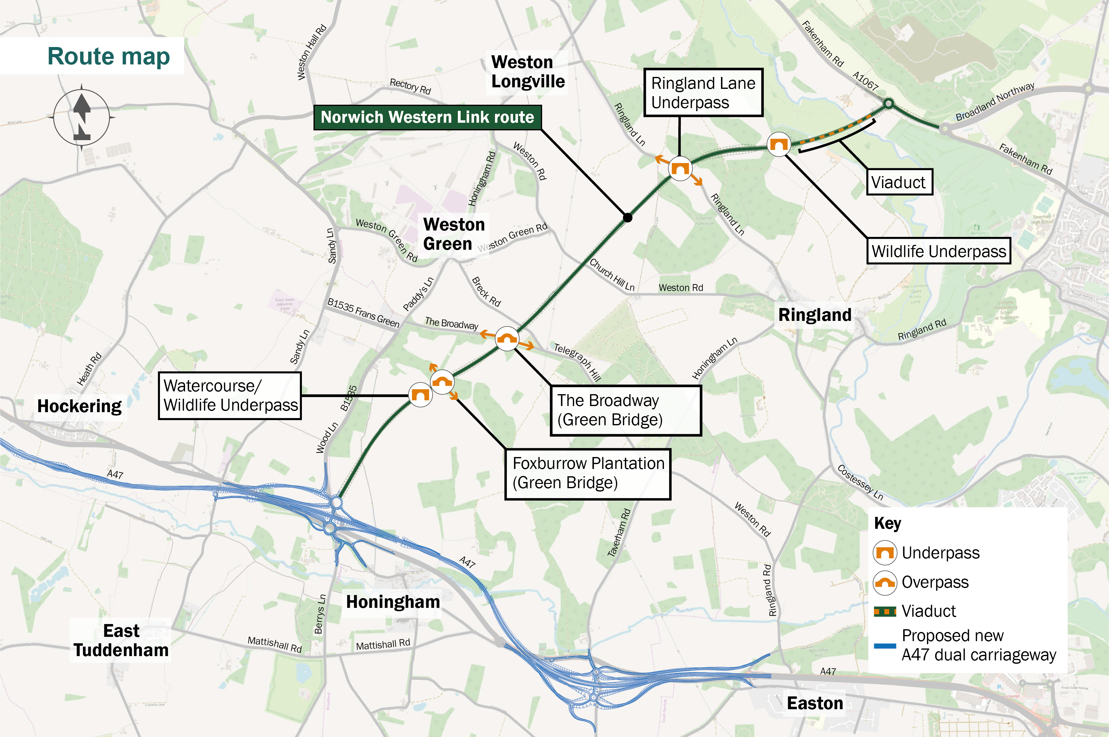
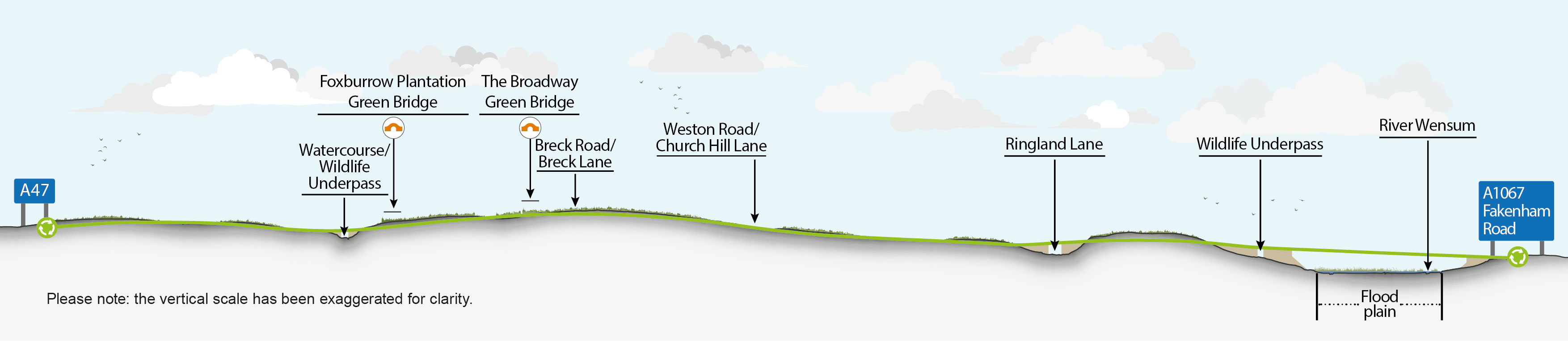
Four existing roads cross the route of the proposed Norwich Western Link. Our proposals for these roads are summarised below and more details on our proposals for each road are provided further ahead in these consultation materials. Please note that where we are proposing to close any roads, access to property will be maintained.
- Ringland Lane – two options: to keep the road open to all through traffic; or for it to be restricted to walkers, cyclists and horse riders only. Both options would see Ringland Lane cross under the Norwich Western Link.
- Weston Road (a section of which is also known as Church Hill Lane) – to be entirely closed to through traffic.
- Breck Road (also known as Breck Lane) – to be entirely closed to through traffic.
- The Broadway – kept open as a through route to walkers, cyclists and horse riders only via a green bridge over the Norwich Western Link, which would also serve as a wildlife crossing.
In developing these proposals, we have considered a number of factors, including: feedback from local parish councils; current usage of these roads and potential impacts on journeys across the wider transport network; local topography, environmental considerations and mitigation requirements, and value for money.
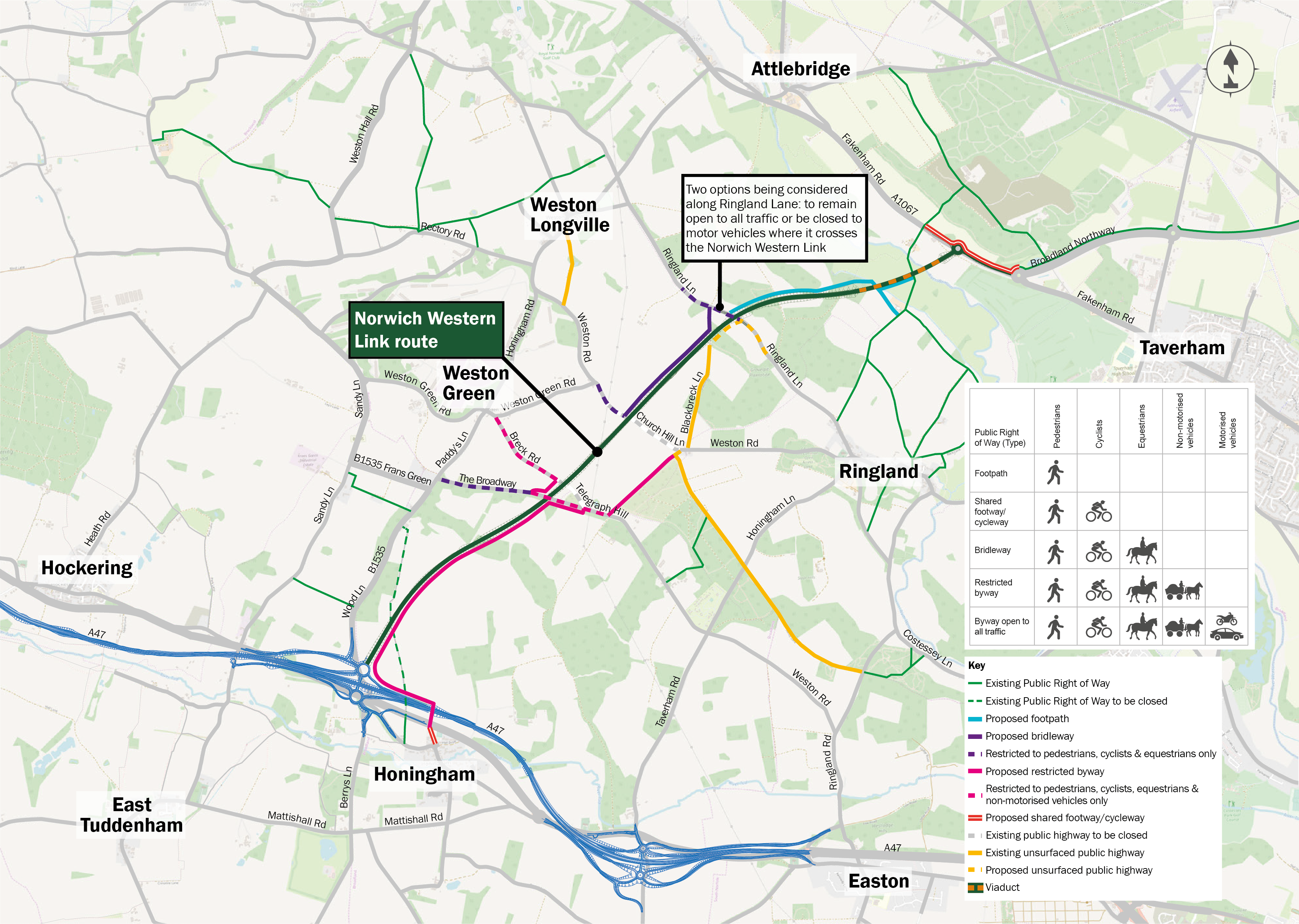
Changes to Public Rights of Way close to the Norwich Western Link
To help encourage travel by more sustainable forms of transport, such as walking and cycling, we’ve been looking at how we could improve the Public Rights of Way close to the Norwich Western Link route. A Public Right of Way is a route over which the public have the right to pass - footpaths, bridleways, restricted byways and byways are all Public Rights of Way.
An overview of our proposals close to the route is shown here, and more detail is given further ahead in these consultation materials. In coming up with these proposals, we’ve sought ideas from representatives of local parish councils and others including walking, cycling and horseriding groups. We have also been working with Highways England, so that our proposals at the southern end of the Norwich Western Link connect with theirs for the North Tuddenham to Easton dualling scheme. Together our plans will help people to safely cross the A47.
At the north end of the route we’re proposing that the Public Right of Way which currently crosses the River Wensum is kept as a public footpath, for consistency with onward routes to which it connects and to avoid impacts on the integrity of the River Wensum Special Area of Conservation.
Sustainable transport measures across the wider area
We want to build upon the benefits the Norwich Western Link road will create for pedestrians, cyclists and public transport and bring in some additional measures to support more sustainable forms of transport. These potential measures would complement the Transport for Norwich project, which is making it easier to travel in and around the city, with a focus on clean and shared transport.
Why your views matter
We began the process to find a contractor for the Norwich Western Link in June 2020 by advertising the opportunity. Once appointed, the contractor will be responsible for the design of the road and its construction.
Following the preferred route announcement and subsequent work to develop the project, we are now in a position to share some of our proposals and get people’s feedback. We want to do this now so that this feedback can be taken into account and inform our ongoing work and the bidding contractors during the procurement process. The contractors will be expected to progress their proposed design for the Norwich Western Link in the run-up to one of them being appointed.
What happens next
We are working to the following timetable, some of which is subject to all the necessary statutory processes for a project of this kind being completed.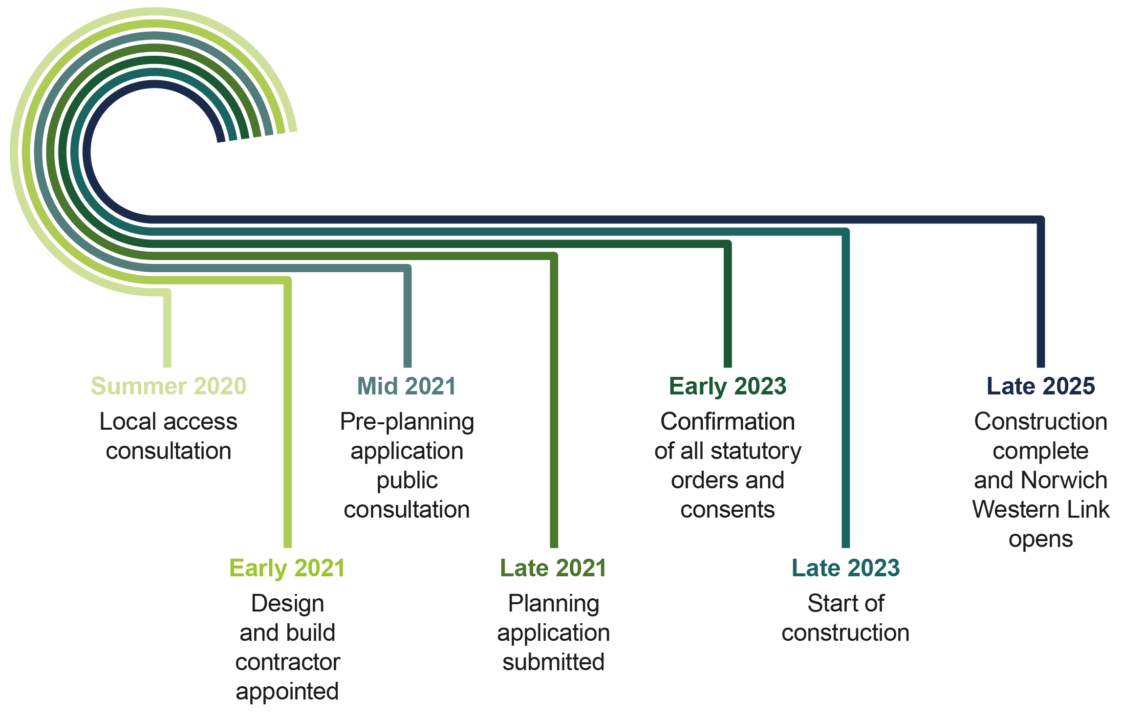
Areas
- All Areas
Audiences
- All residents
Interests
- Planning
Share
Share on Twitter Share on Facebook